
YELLOWMAPS
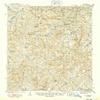
YellowMaps Mt Judea AR topo map, 1:62500 Scale, 15 X 15 Minute, Historical, 1940, Updated 1949, 20.8 x 16.9 in - Polypropylene
CA$229.41
CA$382.35
-
 Order within 2 hours and 32 minutes to get between June 27 - July 3
 -
 Tracked Shipping on All Orders
-
 14-Day Returns
- Secure Payments
-
 24/7 Customer Support
Description
- Printed on Polypropylene (plastic)
- USGS topographic map of Mt Judea, AR, at 1:62500 scale. Heavier material. Waterproof. Tear-resistant. Foldable. Perfect for the outdoors.
- Cities, towns, villages: Deer,Chancel,Red Rock,Lurton,Diamond Cave,Crossroad,Vendor,Piercetown,Holt (historical),Carver,Spence Jucntion,Pleasant Hill,Mount Judea,Cowell,Gum Springs,Parthenon
- Islands: Consult topo map preview for visible islands.
- Parks and forests: Buffalo River State Wildlife Management Area,Alum Cove Natural Bridge Recreation Area
Shipping and Returns
- We offer tracked shipping on all orders. Tracking information will be shared as soon as the order is dispatched.
- Please check the delivery estimate before adding a product to the cart. This is displayed for every product on the website.
- Available shipping methods and charges will be displayed at the time of checkout, depending on your exact location.
- All customers are entitled to a return window of 14 days, starting from the date of delivery of the product(s).
- Customers are advised to read our return policy for details of the return process, eligibility, refunds as well as cancellations or exchanges.
- In case of any issues or concerns about Shipping or Returns, please contact us and we will be happy to help.
YellowMaps.
YellowMaps Mt Judea AR topo map, 1:62500 Scale, 15 X 15 M...
CA$229.41
CA$382.35