
YELLOWMAPS
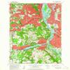
YellowMaps Lake Oswego OR topo map, 1:24000 Scale, 7.5 X 7.5 Minute, Historical, 1961, Updated 1962, 26.8 x 22 in - Tyvek
CA$247.35
CA$412.25
-
 Order within 2 hours and 30 minutes to get between June 27 - July 3
 -
 Tracked Shipping on All Orders
-
 14-Day Returns
- Secure Payments
-
 24/7 Customer Support
Description
- Printed on Tyvek® (synthetic)
- USGS topographic map of Lake Oswego, OR, at 1:24000 scale. Lighter material. Waterproof. Tear-resistant. Foldable. Very durable. Perfect for backpacking and the outdoors.
- Cities, towns, villages: Westmoreland,Marquam Hill,Rivergrove,Johns Landing,Brooklyn,Bryant,Christie (historical),West Portland Park,Briarwood,Oak Grove,Hillsdale,Capitol Hill,Glencullen,Dunthorpe,Bridlemile,Concord,South Lake Oswego,Lake Grove (historical),Marylhurst,Milwaukie Heights,Robinwood,Villa Ridge,Vermont Hills,Fair Oaks,Burlingame,West Portland,Shadowood,Jean,Multnomah,Kellogg Park,Milwaukie,Fulton (historical),Riverdale,Rosewood,Waverly Heights,Bertha (historical),Riverwood
- Mountains: Mount Sylvania,Council Crest,Cooks Butte,Iron Mountain
- Valleys: Low elevation topographic features such as flatlands, river valleys, and canyons.
Printed on Tyvek
Shipping and Returns
- We offer tracked shipping on all orders. Tracking information will be shared as soon as the order is dispatched.
- Please check the delivery estimate before adding a product to the cart. This is displayed for every product on the website.
- Available shipping methods and charges will be displayed at the time of checkout, depending on your exact location.
- All customers are entitled to a return window of 14 days, starting from the date of delivery of the product(s).
- Customers are advised to read our return policy for details of the return process, eligibility, refunds as well as cancellations or exchanges.
- In case of any issues or concerns about Shipping or Returns, please contact us and we will be happy to help.
YellowMaps.
YellowMaps Lake Oswego OR topo map, 1:24000 Scale, 7.5 X ...
CA$247.35
CA$412.25