
YELLOWMAPS
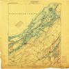
YellowMaps Alexandria Bay NY topo map, 1:62500 Scale, 15 X 15 Minute, Historical, 1903, 20.1 x 16.5 in - Polypropylene
CA$229.41
CA$382.35
-
 Order within 15 hours and 39 minutes to get between June 29 - July 5
 -
 Tracked Shipping on All Orders
-
 14-Day Returns
- Secure Payments
-
 24/7 Customer Support
Description
- Printed on Polypropylene (plastic)
- USGS topographic map of Alexandria Bay, NY, at 1:62500 scale. Heavier material. Waterproof. Tear-resistant. Foldable. Perfect for the outdoors.
- Cities, towns, villages: Redwood,Saint Lawrence Park,Browns Corners,Godfreys Corner,Alexandria Bay,Schermerhorn Landing,Westminster Park,Bean Hill Crossing,Collins Landing,Goose Bay,Pinehurst Resort,Edgewood Park,Point Vivian,Alexandria Center,Plessis,Chippewa Bay,Moore Landing,Omar
- Islands: Hemlock Island,Clouds Rest Island,Arcadia Island,Lotus Island,Holiday Island,Whiskey Island,Lone Pine Island
- Parks and forests: Cedar Island State Park,Grass Point State Park,Keewaydin Point State Park,Indian River Wildlife Management Area,Mary Island State Park,Cranberry Creek Wildlife Management Area,Kring Point State Park
Printed on Polypropylene
Shipping and Returns
- We offer tracked shipping on all orders. Tracking information will be shared as soon as the order is dispatched.
- Please check the delivery estimate before adding a product to the cart. This is displayed for every product on the website.
- Available shipping methods and charges will be displayed at the time of checkout, depending on your exact location.
- All customers are entitled to a return window of 14 days, starting from the date of delivery of the product(s).
- Customers are advised to read our return policy for details of the return process, eligibility, refunds as well as cancellations or exchanges.
- In case of any issues or concerns about Shipping or Returns, please contact us and we will be happy to help.
YellowMaps.
YellowMaps Alexandria Bay NY topo map, 1:62500 Scale, 15 ...
CA$229.41
CA$382.35