
YELLOWMAPS
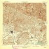
Yauco PR topo map, 1:30000 Scale, 7.5 X 7.5 Minute, Historical, 1946, 21.3 x 19.6 in - Tyvek
CA$293.97
CA$489.95
-
 Order within 15 hours and 30 minutes to get between June 29 - July 5
 -
 Tracked Shipping on All Orders
-
 14-Day Returns
- Secure Payments
-
 24/7 Customer Support
Description
- Printed on Tyvek (synthetic)
- USGS topographic map of Yauco, PR, at 1:30000 scale. Lighter material. Waterproof. Tear-resistant. Foldable. Very durable. Perfect for backpacking and the outdoors.
- Cities, towns, villages: Extension Santa Elena De Monte II,Magas Arriba Comunidad,Santa Maria,Palomas Comunidad,El Faro,Hacienda Belgodere,Hacienda Chesari,Hacienda Fernndez Rosal,Yauco Zona Urbana,Santa Elena,Piedras Blancas,Hacienda Mogote,Villa del Rio,Los Indios,Villa Milagros,Hacienda Loyola,Almcigo Bajo,San Agusto,La Quinta,Reparto La Esperanza,Residencial Padre Nazario,Cambalache,Hacienda Florida,Macan,Hacienda Catalina,Arturo Lluberas,Santo Domingo,Limas
- Mountains: Cerro Candiles,Cerro El Peligro,Cerro La Tuna,Cerro El Alto,Cerro Curet,Pico Rodadero,Piedra de la Mula,Las Cruces,Cerro Limones,Montes de Barina,Cerro de las Avispas
- Valleys: Quebrada Limn,Quebrada La Granja,Quebrada Consejo,Quebrada de los Cedros,Quebrada Caracoles,Quebrada Rodadero,Quebrada Berrenchn,Quebrada Guama,Quebrada Grande,Quebrada Susa,Quebrada La Luisa
USGS topographic map of Yauco, Puerto Rico, dated 1946.
Includes geographic coordinates (latitude and longitude), lines of elevation, bodies of water, roads, and more. This topo quad is suitable for recreational, outdoor uses, office applications, or wall map framing.
Printed on-demand by YellowMaps on the print material of your choice.
Shipping rolled from Minneapolis, MN, United States.
Product Number: USGS-5655600
Map Size: 21.3 inches high x 19.6 inches wide
Map Scale: 1:30000
Map Type: POD USGS Topographic Map
Map Series: HTMC
Map Version: Historical
Cell ID: 50056
Scan ID: 362605
Visual Version Number: 1
Datum: Puerto Rico
Map Projection: Polyconic
Map published by United States Geological Survey
Map Language: English
Scanner Resolution: 600 dpi
Map Cell Name: Yauco
Grid size: 7.5 X 7.5 Minute
Date on map: 1946
Geographical region: Puerto Rico, United States
Northern map edge Latitude: 18.125
Southern map edge Latitude: 18
Western map edge Longitude: -66.875
Eastern map edge Longitude: -66.75
Surrounding map sheets (copy & paste the Product No. in the search bar):
North: USGS-5654848,USGS-5654852,USGS-5655384,USGS-5655386,USGS-5654850
East: USGS-5654892,USGS-5654898,USGS-5655434,USGS-5654896,USGS-5654894
South: USGS-5655504,USGS-5655506,USGS-5654970,USGS-5654968,USGS-5655508
West: USGS-5686505,USGS-5655002,USGS-5655536,USGS-5655540,USGS-5686507
Shipping and Returns
- We offer tracked shipping on all orders. Tracking information will be shared as soon as the order is dispatched.
- Please check the delivery estimate before adding a product to the cart. This is displayed for every product on the website.
- Available shipping methods and charges will be displayed at the time of checkout, depending on your exact location.
- All customers are entitled to a return window of 14 days, starting from the date of delivery of the product(s).
- Customers are advised to read our return policy for details of the return process, eligibility, refunds as well as cancellations or exchanges.
- In case of any issues or concerns about Shipping or Returns, please contact us and we will be happy to help.
YellowMaps.
Yauco PR topo map, 1:30000 Scale, 7.5 X 7.5 Minute, Histo...
CA$293.97
CA$489.95