
YELLOWMAPS
Mt Baden Powell CA topo map, 1:24000 Scale, 7.5 X 7.5 Minute, Historical, 1940, Updated 1940, 20.5 x 17.4 in - Tyvek
CA$247.35
CA$412.25
-
 Order within 6 hours and 10 minutes to get between July 4 - July 10
 -
 Tracked Shipping on All Orders
-
 14-Day Returns
- Secure Payments
-
 24/7 Customer Support
Description
- Printed on Tyvek (synthetic)
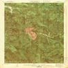
- USGS topographic map of Mt Baden Powell, CA, at 1:24000 scale. Lighter material. Waterproof. Tear-resistant. Foldable. Very durable. Perfect for backpacking and the outdoors.
- Cities, towns, villages: Johnson Corner
- Mountains: Mount Baden-Powell,Inspiration Point,Throop Peak,Ross Mountain,Mount Burnham
- Valleys: Cedar Canyon,Falls Gulch,Bear Gulch,Alder Gulch,Dorr Canyon,Grassy Hollow,Fenner Canyon,Ross Gulch,Mine Gulch,Vincent Gulch
Printed on Tyvek
Shipping and Returns
- We offer tracked shipping on all orders. Tracking information will be shared as soon as the order is dispatched.
- Please check the delivery estimate before adding a product to the cart. This is displayed for every product on the website.
- Available shipping methods and charges will be displayed at the time of checkout, depending on your exact location.
- All customers are entitled to a return window of 14 days, starting from the date of delivery of the product(s).
- Customers are advised to read our return policy for details of the return process, eligibility, refunds as well as cancellations or exchanges.
- In case of any issues or concerns about Shipping or Returns, please contact us and we will be happy to help.
YellowMaps.
Mt Baden Powell CA topo map, 1:24000 Scale, 7.5 X 7.5 Min...
CA$247.35
CA$412.25